“Oh, how I wish I had the power to describe the wonderful country as I saw it then.”
James B. Gillett entered West Texas in the 1870s, as a Texas Ranger. The “wonderful country” he saw was no virgin land, no timeless terrain – Native Americans had long modified the landscape, and aridity has steadily intensified here since the Ice Age. But as Gillett himself was well-positioned to observe – he lived till 1937, and is buried in Marfa – the scale and speed of change after European arrival was dramatic. Prairies became shrublands. Timber stands vanished. Wetlands, springs and streams disappeared. Today, 95 percent of the water that once flowed through the Big Bend canyons is gone.
As many West Texans increasingly consider how to nurture what remains, and even restore what was lost, glimpses of “the wonderful country” of yore can be of immense practical value. Historic photographs are especially helpful.
Jeff Bennett, a conservation delivery specialist with the American Bird Conservancy, has worked in restoration projects in the Big Bend for two decades.
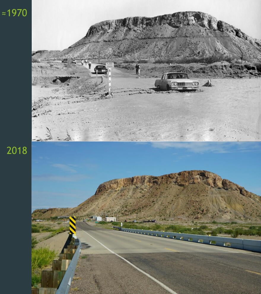
“They're driving across the creek bottom,” Bennett said, “and in the next photo, that creek bottom is where the bridge is, basically. The creek bottom is 15 feet below. There's bedrock in the bottom of that stream now, so it raced to the bottom, to the bedrock. I suspect that is because of gravel mining upstream to build the roads in the Big Bend.”
Bennett is showcasing two photos of Rough Run Creek, near Study Butte – one from 1970, the other from 2018.
The change is dramatic – from an open stream bed with a broad floodplain, to a deeply incised arroyo. Clearly, radical changes to the landscape didn't end with the first flush of modern settlement, but have continued.
Riparian areas – stream corridors – have been particularly impacted.
Gillett himself – who left law enforcement to ranch in the Big Bend – gives us a glimpse of this very spot. His crew, he says, could park a thousand head of cattle in the cottonwood shade at the confluence of Rough Run and Terlingua creeks. Terlingua Creek itself, he writes, was a “bold running stream, studded with cottonwood” and “alive with beaver.” Fish thrived.
Terlingua Creek is rarely “bold running” today. And there's little shade for cow or cowhand. Where did it go?
“We know that the Study Butte Mining Corporation bought 4 miles of cord wood in three years,” Bennett said. “The mine was open for 30. And there were three, maybe four mining companies.”
Mercury mining operations near Study Butte, and, later, silver mines in Shafter, needed timber. Pine from the mountains was preferable, but they likely took what they could get.
The complexity of ecosystems strains comprehension. Likewise, ecosystem change is never simple. But there are patterns that seem to apply across the Southwest.
With fewer trees to intercept rainfall, water came harder and faster down stream beds. Downcutting occurred. Over time, flooding streams no longer leapt their banks. With this “broken hydrology,” there was no way for floodplain vegetation to rebound.
Bennett, and partners including Texas Parks & Wildlife, the U.S. Fish & Wildlife Service and others, are working with landowners to mitigate or reverse some of these changes. One technique is “brush weirs” – “leaky dams” installed along stream courses. These features mimic the effects of beaver.
Sediment can accumulate behind the weirs, slowly filling in downcut stream beds. Streams are reconnected with floodplains. The weirs don't reduce the amount of water delivered downstream, Bennett said – they only slow its progress. Streams that today are intermittent or ephemeral could become perennial again.
Historic photographs can be a vital aid in such restoration efforts. Images of what was – can clarify what could be again. West Texans might consider sharing family photo collections, Bennett said.
“There aren't a lot of collections out there, that have been turned into archives,” he said. “Your grandparents photos – you might not think they're very valuable, but they are, and sharing them with a guy like me, or a university archive, isn't necessarily a bad thing. It could be helpful.”
From the High Plains to the desert-mountains, West Texas remains a “wonderful country.” But there is much to be nurtured and restored – and, as the search for historic photos shows, surprising ways to do it. Listeners interested in sharing photos can email Bennett, at jbennett@abcbirds.org.


